Monthly Archives: April 2014

Online Security

Based on the presentation on wednesday, nothing I do online is safe.  I really do not do many activities that requires any advanced personal information.  I use Google and Youtube and get recommendations  based on my history and that is about it.  I do not often make purchases online and I am only registered to a few sites; none of which require more than my name and e-mail address.

Finding items for my project has not been extremely difficult but has become more challenging recently.  I have used all the images that the Library of Congress has offered on my subject, and that I can legally use.  I have eight items in my database and have ideas for two more (another video and visualization) but that is about it.  I found some photographs on a blogpost that were relevant but to obtain the rights to them involved a long process and a fee. All of the items have relevance, but the only item that I have that I consider especially useful is a diagram that shows the extent of the damage inflicted during the riots.
Omeka Exhibit

The exhibit I am planning in Omeka is going to be a visual examination of the neighborhoods affected by the 1968 D.C. riots.  The exhibit will begin with a page, that has a video containing raw footage of the riots and a map showing the extent of the destruction, to introduce the audience to the subject.  Next, will be a series of pages that contain one to two images of each neighborhood paired with a light amount of text discussing how the area was affected directly by the riots.

D.C. Riots Vietnam War (Video not yet uploaded to Omeka)

City Wide Damage Report

 D.C. riot. April ’68. Aftermath / [WKL].

DC Riot Aftermath

Soldiers Stand Guard

National Guard

U Street

Text Mining Tools and Project Progress

Text mining tools like Wordle and Google Ngram are of basically no use to me for my project.  I do not believe these tools should be used for any formal project except, maybe, to get very basic statistical data from Ngram.  Wordle is really more of an art project application that can be used to kill time and not much else; it does show you the prevalence of certain words but it does nothing that can aid a project.  Neither of these tools will be of much use to me when I am trying to show the effect of the 1968 Washington D.C. riots.

I have not made much progress on my project in terms of actual physical work on the Omeka account or on the paper but I have narrowed down my topic to a point where it easier to explore, and found a few more resources that will be helpful.  My research will focus on the affect the Riots had on the surrounding neighborhoods.  The paper should now be more focused and easier to assemble, however I still need to find more resources with useful information.

Map Assignment

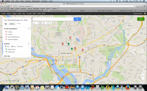
Screen Shot 2014-04-03 at 4.07.52 PM


1968 Washington D.C. Riots

When designing my map, I chose just to do a general overview of the riots by pointing out the areas that were affected.  In the first layer, I pinpointed all the neighborhoods that were involved and added a small informational bit with an historic image of the location.  In the second layer, I only added points that showed where the riots began and ended.  I did not draw any lines or shapes to connect the points because while there were clear spots where the riots started and finished, the riots occurred in several neighborhoods at once therefore any diagram would be confusing and unnecessary.  I could not think anything else to do with the map; this topic can only can only be analyzed in map form by showing the places the event occurred in.  There is nothing more that could be shown, except maybe adding the statistics of the damage in the description.

My map did not help me much in learning more about my topic because mapping is unlikely to provide information on how the neighborhoods were affected.  The map can show the total area that was damaged but not much more.  I can see what was affected but not how it was affected.  It is hard to determine cause and effect relationships looking only at an online map.